


1-1 Jera Building Voting District, Humphreys County, Tennessee
About
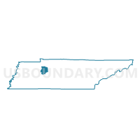
Outline

Summary
| Unique Area Identifier | 668884 |
| Name | 1-1 Jera Building Voting District |
| County | Humphreys County |
| State | Tennessee |
| Area (square miles) | 15.06 |
| Land Area (square miles) | 11.53 |
| Water Area (square miles) | 3.53 |
| % of Land Area | 76.55 |
| % of Water Area | 23.45 |
| Latitude of the Internal Point | 36.04955440 |
| Longtitude of the Internal Point | -87.95992470 |
Maps


Graphs
Select a template below for downloading or customizing gragh for 1-1 Jera Building Voting District, Humphreys County, Tennessee


Neighbors
Neighoring Voting District (by Name) Neighboring Voting District on the Map
- 1 Holladay School Voting District, Benton County, TN
- 1-2 Armory Voting District, Humphreys County, TN
- 4 Camden Elementary School Voting District, Benton County, TN
- 4-5 FUMC Voting District, Humphreys County, TN
Top 10 Neighboring County Subdivision (by Population) Neighboring County Subdivision on the Map
- District 1, Benton County, TN (2,939)
- District 4, Humphreys County, TN (2,710)
- District 4, Benton County, TN (2,636)
- District 1, Humphreys County, TN (2,531)
Top 10 Neighboring Place (by Population) Neighboring Place on the Map
Top 10 Neighboring Unified School District (by Population) Neighboring Unified School District on the Map
Top 10 Neighboring State Legislative District Lower Chamber (by Population) Neighboring State Legislative District Lower Chamber on the Map
Top 10 Neighboring State Legislative District Upper Chamber (by Population) Neighboring State Legislative District Upper Chamber on the Map
Top 10 Neighboring 111th Congressional District (by Population) Neighboring 111th Congressional District on the Map
Top 10 Neighboring Census Tract (by Population) Neighboring Census Tract on the Map
- Census Tract 1303, Humphreys County, TN (5,599)
- Census Tract 9634, Benton County, TN (4,226)
- Census Tract 9631, Benton County, TN (3,074)
- Census Tract 1305, Humphreys County, TN (3,061)
- Census Tract 1302, Humphreys County, TN (1,897)